
Walk 9 - Hartburn Woodland Walk - Easy Route
Distance: 2 miles (3.2km)
Maps: Explorer OL42
Walking time: 1 hour
Start and Finish point: Hartburn car park in the centre of the village (Nz 089860). Hartburn is situated on the B6343 between Morpeth and Cambo.
DOWNLOAD the free self led walking guide for Hartburn Woodland Walk from here
Summary
This must be one of the little known gems in Northumberland. A short woodland walk following the ‘Hart burn’ for a short distance, with lots of interesting points to explore on the way. This walk is suitable for people of all ages, including toddlers, but good shoes may be required.
Hartburn is one of the most attractive villages in Northumberland and is unspoilt by modern developments. There is a sound of water everywhere as the burn tumbles down the steep sided valley.
Route Details
Turn left out of the car park and follow the road through the beautiful village of Hartburn. Its sandstone and slate houses have changed little over the last 100 years. On the first corner you pass a small village hall with a clock on the end and the village notice board.
About 100 yards further up the road you pass a peculiar triangular building. This gothic folly was built in 1757. The ground floor was used as a parish stable, with the schoolroom above and finally in the eaves a rather cramped school masters accommodation.
Continue past the old school for a short distance and the wood will start on your right hand side, with a wooden fence boundary. Turn right into the wood at the footpath sign (Hartburn Glebe). This wood is owned by the Woodland Trust, and there is a small sign welcoming you to their wood as you enter.
Follow the steps, bearing right at the fork and wind your way down to the burn.
In spring the wood is filled with bluebells and wild garlic. What a wonderful ambience the air has around the wood with the smell of the garlic and the wild flowers and the trickle of the burn in the background.
As the river and path bends round to the left walk down to the rapids on your right. Opposite you is a spectacular rockface with trees growing out of it. In front of the rockface in the river there is a deep pool known as ‘Cobblers Hole’. This was once thought to be bottomless. A local story says that when the Vikings were raiding Northumberland, the locals put all their valuables in a chest that the baker used to keep his flour in and they lowered it to the bottom of Cobbler’s hole on the end of a rope. When the Vikings had passed on, they tried to pull the chest up but the rope broke and the chest disappeared in to the depths of the hole, never to be seen again.
Just as you go round the corner, where the water is calmer, you may be able to see two parallel lines cut in to the bedrock crossing the river. This is thought to be the remains of a wooden bridge, part of a Roman road (Devils Causeway).
Carry on a little further upstream and you will come to Dr. Sharp’s Grotto. Dr Sharp was a great eccentric who lived in Hartburn in the eighteenth century. He cut this grotto, which has two rooms, out of the solid rock face. It was used as changing rooms for himself and his guests when they went swimming. In front of the grotto you can see a tunnel leading to the river. The ladies used this so they could reach the river without the gentlemen seeing them. Above the entrance are two ledges. On these once stood statues of Adam and Eve.
Continue along the track with the river on your right and the track starts to climb.
Bear left at the fork as you continue to rise and after a few yards turn left off the main track up a track which rises as you double back on yourself.
Continue along the track following the fence on your right, with a grass field on the far side of it.
Follow the fence as it passes through 90 degrees to the right and continue on with the fence on your right. After a little while you drop down and cross a broad track with a house up to your right.
Continue on along the path and cross a stone bridge before bearing right back up to the road. Turn left along the road and walk down it.
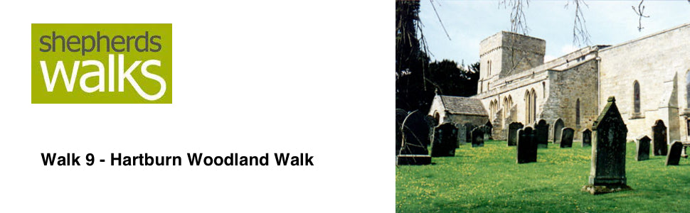
Before returning to your car, visit St Andrew’s Church, situated just opposite the car park. The church tower was built in 1080AD, and the remainder built in the 12th and 13th centuries. It belonged to the monks of Tynemouth abbey. In 1966 during renovation work on the tower skeletons were discovered in shallow graves. These remains are thought to be the remains of the monks themselves.
Inside the church the ‘colours’ hanging in the roof space are the battle honours of the peninsular war in Spain and Portugal against Napoleon. Another interesting feature is the Leper’s windows. Situated to the right of the pulpit and also to the right of the altar. Leprosy was such a terrifying disease in medieval England that to try and stop the spread of it they were separated from the rest of society. They could only watch and listen to services through these small windows.
There are both guidebooks and leaflets about the church history available at the entrance of the church for a small donation. Also close to the entrance is a moneybox used by Cromwell to store the wages of his soldiers during the Civil war.
Revised November 2004