
Walk 5 - Lordenshaws - Moderate Route
Distance: 7.5 miles (12 km)
Maps: Explorer OL42
Walking time: 2 ¾ hours
Start and Finishing point: Lordenshaws car park (NZ 053988). This is a Northumberland National Park car park. If you are approaching from Rothbury on the B6342 turn first right (signposted Simonside 2), about 2 ½ miles out of the village centre. The car park is a little way up this road on your right.
DOWNLOAD FREE WALKING GUIDE - LORDENSHAWS
Walk Summary
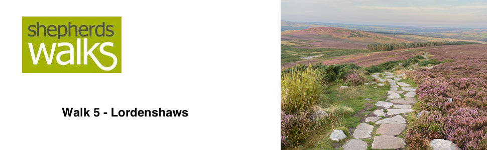
This walk rewards you with some of the nicest views in Northumberland, in my opinion. The ridge between Dove crag and Simonside has some spectacular views on a clear day.
The walk starts with a fairly steep, but short climb, so that you quickly gain height. Then you have an exceptional section, keeping your height for a good distance, where magnificent views are experienced.
You then drop down through the forest and some lovely farmland where the views looking back at Simonside in the distance are quite spectacular.
On your return to the car park you pass, and can explore, Lordenshaws Iron Age fort, which has a wealth of archaeological remains.
Route Details
From Lordenshaws car park go out of the entrance, cross the road and start climbing up the path in front of you (Footpath sign (FP) Spylaw 1 ¼: Coquet Cairn 2 ½).
After a short distance bear right at a marker post (MP) and follow arrow for ‘Permissive footpath’.
The path turns wide and well trodden, as you continue to climb. If you get tired, don’t worry this is the hardest part. Stop, turn around and look back at how high you have climbed.
You climb up to 360 metres (1200ft) and then the path levels out for a while. This is a good place to get your first good view of Rothbury, with the River Coquet winding it’s way into it.
Continue on, cross the style and start climbing again, following the main path. Bear left as you climb. Do not follow the red arrow. You soon reach Dove crag, which is 395 m (1300ft). From here you can follow the coastline on a clear day.
The cairn topping Dove crag is a prehistoric burial cairn.
Follow the ridge for just over half a mile until you reach Simonside Crags (429m/1400ft). As you follow the ridge you can see Fontburn Reservoir away to your left, and the Cheviots away in the distance to the Northwest.
The crags situated below the summit of Simonside are very famous and are mentioned in “The Climbers Journal” dated 1902! As such they were the first crags, in Northumberland, to be recognised and there are more than one hundred different routes up the rock face.
As you reach the crags, follow the path along the top of them and then continue as the path drops down steeply to the forest track below.
Turn right and follow the forest track for over half a mile, as it skirts below the higher ground, which lies to your right. Keep to the main track as it turns through ninety degrees to the left, follow the red arrow.
The track slowly descends and one hundred yards after the trees have started on both sides, turn right, down a path into the forest (red arrow pointing path out).
Carry on descending through the forest as you cross over another path, with a stream and wooden bridge to the right.
Eventually you come out at a clearing, with two picnic tables in it and a car park away to your left. Bear right across the clearing, passing the second picnic table, to a path in the corner near the road.
Follow the path, as it runs parallel to the road. As you reach the road, turn right along it, cross the cattle grid. Immediately after turn left, through a small gate (FP Whitton Hillhead ½: Whitton 2)
Follow the path, pass through another small gate and continue up the edge of the field. After passing a small disused quarry, turn right through the gate (MP marking Bridleway).
The path continues up the side of the field, through another gate (BW marker on gate) and continues until you reach another gate to the right of a large shed.
Go through the gate, turn right and follow the track as it skirts round the front of ‘Whitton Hillhead’ farmhouse. Keep following the main track for about half a mile, as you cross three cattle grids.
You will see ‘Sharp’s Folly’ in the distance. Thomas Sharp, who was the rector of Rothbury between 1720 and 1758, built this. Sharp used the tower as an observatory when he was studying the stars.
As you start to drop down, after the third cattle grid, turn right up the first track, which leads to Whittondean farm. As you reach the farm go straight on, through a small gate situated by the side of the house (FP marker on gate). After passing the house go through another gate and turn right immediately (yellow arrow on gate).
The track then drops down, with a small lake to the right. Cross the stream coming out of the lake and turn right towards a gate (PF marker on gate)
After going through the gate follow the white marker stones, as you bear left up the field. The path climbs up steeply until you reach a ruined wall. Go through the wall, turn right (PF marker post) and continue climbing.
You soon reach Lordenshaws Iron Age hillfort, to your left. It has a wealth of archaeological remains of earthworks, trackways and a burial cairn, which reflects thousand of years of human activity. Today traces of several round stone houses can be seen inside the fort, these belong to a later settlement built during the Roman occupation.
You are free to walk and explore the archaeological sites thanks to an agreement between the Duke of Northumberland and the tenant farmer.
If you do not go left into the fort, carry straight on along the footpath and return back to the car park.