
Walk 4 - Fontburn Reservoir - Moderate route
Distance: 8.6 miles (13.85 km)
Maps: Explorer OL42
Walking time: 4 hours
Start and Finish point: Harwood. Harwood car park (glorified lay by). (Grid ref - NZ 002902). If you are approaching Harwood on the B6342 (travelling north) take the second left after Cambo (signposted Harwood, Elsdon). Take the first right turn signposted Harwood Village. Before you reach Harwood village the car park is signposted off to your left and is just a layby on the right a few hundred yards down the track.
DOWNLOAD THE WALKING GUIDE FOR FONTBURN RESERVOIR FROM HERE
Summary
This is a nice gentle walk that involves little climbing but still gives you the satisfaction of more strenuous walks. There are some interesting points on route.
It explores some of the little known gems of Northumberland.
The walk starts with a forest section and then the beautiful Greenleighton moor, as you look down on Fallowlees burn winding its way to the reservoir.
The section of the walk that skirts Fontburn reservoir is exquisite and relatively hard to get to, therefore it is so unspoilt. You then return via Fallowlees farm, which is a nice walk through Harwood forest on good paths.
As many of the paths in this area are not walked very often they may not be clear under foot, so please use this route guide in conjunction with an Ordnance Survey map.
The walk is mostly good under foot but strong shoes are recommended.
Route Details
From the lay-by you parked in walk back in the direction you originally drove in. Upon reaching the T-junction turn left along the tarmac road, heading north towards Harwood Village.
As you reach the main group of houses in the village turn left sharply (Public Bridleway sign, Redpath Farm 1 ½), taking the wide forest track into the forest itself, which leads you away from the village. Pass the ‘No entry to unauthorised vehicles’ sign and follow the main track, ignoring all paths and tracks leading from it, as you gradually climb up the broad forest track.
If you look back as you climb you get some splendid views of the lower lying ground.
As the track gently bends round to the left and just before it levels out you turn right along a broad forest track (signposted Redpath, Fallowlees and Chartners, also Public Bridleway sign, Redpath Farm 1 mile).
Continue on the track through the forest ignoring all paths leading from it. As the track opens up you can see the old Redpath Farmhouse in the distance.
Before the forest was planted Redpath farm was a very productive hill farm. Once the forest was planted it was just left with a small amount of ground, which made it unproductive. The ground was then let to a neighbouring farmer and the house was leased to Northumberland Wildlife Trust, until 2002. I do not know what is planned for it in the future.
As you slowly drop down continue on the main track, ignoring the sign posted path going off to your left, the track crosses the Fallowlees Burn before gradually rising up to the farmhouse.
Pass in front of the farmhouse on the track and immediately after this turn right. Leave the track here, pass the broken down stell (small stone built enclosure to hold sheep) on your right and walk directly over to the small gate leading into the forest. Once you stand next to the stell the gate you are heading for is obvious to see. This short section before the forest can be a little overgrown with rushes in the summer months.
Pass through the small gate taking you in to the forest (Public Bridleway sign on it). Follow the path, which is marked with posts that have yellow tape on the top and Public Bridleway arrows on the top of them. If you do loose the path through this short section, don’t worry just bear slightly right and make your way down to the forest lane.
Upon reaching the forest lane (whether by the correct route or not), turn left along it.
Continue down the lane and as you pass through a fire break where no trees are present. Immediately after this you reach a marker post indicating a Footpath and St Oswald’s Way straight on and a Bridleway turning right, down in to the forest.
Take the Bridleway to the right and pass through the forest down to and follow the Fallowlees Burn on the prominent path. Cross the bridge and rise up to a small gate taking you out of the forest on to Greenleighton Moor.
Pass through the gate and continue to rise up to a Bridleway marker post, on the levelled path away from the forest.
Upon reaching the marker post bear left and follow the prominent path which runs along the level ground, with the valley dropping away to your left and the Fallowlees Burn running along the bottom of it.
The moor is a man made feature, grazed in a traditional way with sheep and cattle. If grazing were to stop, then the moor would slowly revert to scrub and woodland. Scottish Blackface sheep and beef cattle graze this moor in winter. The farmer employs an old grazing method called ‘raking’. In the morning, the flock is driven eastwards and then pushed back again later in the day. This enables the moor to be grazed more evenly and for the numbers and condition of the flock to be checked regularly.
You can see a corner of a field on your right. Leave the path you are following and walk to the small gate, located a few yards from the corner of the fence (Public Bridleway sign).
Pass through the gate and walk in the direction of the Public Bridleway arrow on the gate, pointing left and walk through the field with the fence on your left. When you pass over the brow of a small hill you can see down to the bottom of the field.
Head for the gate situated just to the left of some sheep-handling pens, which are made out of galvanised sheets of metal.
As you walk across the field you get your first view of Fontburn Reservoir in the distance.
Pass through the large gate next to the sheep-handling pens and follow the prominent grassy path leading away from the field, heading in the approximate direction of the reservoir.
Just as the path bears round to the right and drops down slightly to a small burn, bear left, heading towards a prominent marker post located on the flat ground in front of you and to your left.
Upon reaching the marker post (arrow on saying – Greenleighton Walk) continue on along the flat ground heading for a tree on the horizon, which is located on its own, just to the left of two small hillocks. The path is not very clear here.
As you continue on you will pass a number of National Trust arrows way marking the Greenleighton Walk.
Upon reaching the single tree walk directly over to the large ladder stile located on the horizon, taking you over a wall.
Cross the stile and follow the path, which runs along the top of the valley that drops away to your left. Follow the Greenleighton Walk way marker posts down to a tree line.
As the path drops down, away to your left where the ground just slightly rises is an ancient burial ground.
This is a Bronze Age burial cairn about 3,000 years old. Different sources give slightly different information about this burial cairn. Some say just one person was buried in the middle and others say that the leader was buried in the middle with all his followers surrounding him around the edge of the mound. One thing that is not disputed though is that the leader in the middle was buried upright, probably in a crouched position.
Upon reaching the tree line, do not pass through it. Bear left and follow the path and follow the way marked ‘Waterside Trail’, with the trees and burn on your right, heading towards the small gate taking you into the wooded section, which surrounds the reservoir.
Pass through the gate and follow the prominent path. In summer a short section of this path, just around the corner can become overgrown with bracken, but this is only for a short distance.
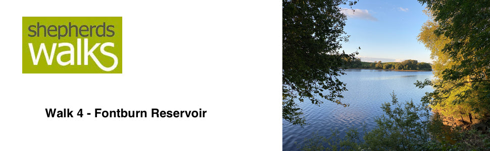
Away to your right you get a lovely view of the reservoir itself. This section of it is a Nature Reserve and is very popular haunt of Herons.
Fontburn Reservoir was built in 1910, to supply water to 300,000 people in Morpeth, Ashington and Whitley Bay. It holds 730 million gallons, covers 84 acres and supplies five and a half million gallons of water each day.
Continue to follow the prominent path, cross over the small footbridge that takes you over the Fallowlees Burn. Stick to the path as it takes you through the woodland.
Upon reaching a burn, bear left, upstream a little way to a footbridge and cross it and continue on as the path runs along the edge of the woodland before rising up through the trees to a small gate.
Pass through the gate up to your right taking you back onto farmland and follow the Northumbrian Water Waterside Trail for a very short distance.
Where the ground levels out a little (and the Waterside Trail goes off to the right) you pass through a sod cast in front of you (the ground is slightly raised on each side of you) leaving the Northumbrian Water Waterside Trail. Continue on and just after you pass through a second sod cast bear left up onto the higher ground, whilst following the sod cast on your left. Upon reaching the top head towards the large galvanised gate, which leads into a small paddock located in front of Newbiggin Farm.
Do not pass through the gate into the paddock but turn left just before you reach it and follow a well worn tractor track down to a single tree located in the middle of the flat area of the field.
Upon reaching the tree continue on along the middle of the flat ground, cross the burn and continue on the flat ground, running parallel to the burn on your right and proceed up to a small gate (note – if the burn is too high to cross, walk upstream a little way and you will find a footbridge. If you do this, after crossing the bridge walk up the fence line on your right and it will take you to the small gate mentioned above).
Pass through the small gate and continue walking directly across the middle of the field to a prominent single tree, located next to the footings of an old footbridge.
Cross the river next to the old footbridge (if the river is high and impassable walk a little way upstream and find somewhere a little easier to cross).
From the sight of the ruined bridge walk in to the middle of the field heading straight for a prominent Hawthorn Bush (located in the direct line of the ruined bridge). Upon reaching the bush, walk to the nearest point of the tree line directly on your left. Cross the burn and pass through the small gate taking you back into the forestry land.
Point –If you are having trouble locating the small gate leading back in to the forestry land follow the burn upstream as it skirts around the edge of the field from the ruined bridge, until you find it.
After you pass through the small gate, walk up the path that runs up to a firebreak (a clear section of ground with trees either side). Continue to follow the path as it runs up the left hand side of the firebreak with mature trees on your left.
When I first wrote this walk ten years ago this section of the walk was a tree covered lane, which was very picturesque, but after the trees were felled and replanted on both sides it has certainly changed it a little. On the positive side it has opened the view up, but it makes you realise how sheltered the trees had been on your right. Now they have been directly exposed to the winds the trees have either toppled over, with such a shallow root, or have snapped like matchsticks.
Continue on the path with the older trees on your left.
When you reach the forest track cross straight over it and continue to follow the path with trees either side of you.
Upon reaching the small gate leading into a field pass through it and head straight across the field heading for the farm, called Fallowlees.
Fallowlees was once a village but was recorded as a solitary shepherd’s house as long ago as 1671. Since then it has survived as a farm.
Forestry has had a major impact on the moorland landscape since large scale planting of conifers started in the 1930’s. In the gloom of agricultural depression there seemed to be a potential benefit that revenue from trees might bring to ‘marginal’ land.
You pass through a gateway in a stone wall before reaching and passing through a small gate situated next to a small low roofed black building.
Continue on and pass through a gate taking you along the front of the farmhouse. Walk along the track in front of the house until you reach the main forest track.
Bear left along the forest track and continue along it ignoring all paths leading from it.
You eventually pass through an area which has been replanted each side of the track. Away to your left you can see where you rose out of the forest earlier on the walk going on to Greenleighton Moor.
Continue along the track and pass through the gate just before you reach Redpath Farmhouse again, which you passed earlier in the walk when you were coming in the opposite direction. Stick to the main forest track as you pass the farmhouse, weave down, cross the Fallowlees Burn and rise up on the track and cross the cattle grid.
Upon reaching the main T-junction turn left and proceed down to Harwood village again. Turn right in the village and proceed along the road.
Turn right and return to your car.