
Walk 25 - Blanchland Moor - Moderate Route
Distance: 6 ½ miles (10.5 km)
Maps: Explorer OL43 and Explorer 307
Walking time: 4 hours
Start and Finish point: Blanchland Car Park (grid reference - NY 964504). From Hexham take the B6306 heading south. After about 12 miles you reach the village of Blanchland. As you enter the village turn right (car park signposted), passing to the left of the White Monk tearoom to the main car park, which you turn left into.
DOWLOAD a PDF of this walk with a map from here.
Summary
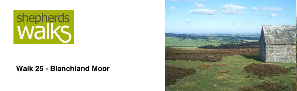
This walk is certainly one of stark contrast, from the lush picturesque scenery around Blanchland to harsh rugged heather clad moorland. From here you get a real sense of isolation and with the scenery being so different from that found in The Cheviots and the hill ground to the north of Hexham.
With very little climbing you are treated to some exceptional views in this historic and fascinating countryside.
The walk is good underfoot, but strong shoes are recommended.
Route Details.
Leave the car park using the same entrance you entered by and turn left to walk up the single track lane. Ignore the track going off to your left leading to Coat House Farm and continue up the lane as it bears slightly to your right. As you continue up the lane you have a wooded section on your right and the ground rising up on your left.
Ignore the public footpath going off to your left and continue on the track as it bears around to your right before crossing the Shildon Burn on a small bridge. The track bears around to your left and gradually rises up and you have some houses up to your right (Shildon).
Ignore the footpath on your right leading off to Blanchland and continue along the single track lane again ignoring the footpath going off to your right.
As you continue to follow the track you have a wooded section initially on your right then after a little while you pass a large tin building also on your right, which is adjacent to an old stone barn.
On your left you can see that the ground that drops away from you has been planted with broad leaved trees. This in the past would not have been very productive agricultural land. More than likely it would have become infested with bracken, meaning that it would not have had any feed value for much of the year for the grazing sheep. In recent years there have been many grants available to plant such areas to make them a haven for wildlife. This will probably be the reason why this area has come to be planted. In such schemes you are very much planting to create a habitat for wildlife, rather than for timber production and that will be why broad leaved trees have been planted.
As the track bends steeply around to the right, leading up to a house, you continue straight on, passing through a large wooden gate. On the left-hand side is a Public Footpath sign and you are walking in the direction of Lady Cross and Burntshield Haugh.
Walk along the prominent track in front of you as the track bears slightly to the right with a stone wall and a wood the far side of it on your right. You rise up and as the track turns steeply to the right you turn left, leaving the track and walk over to a Public Footpath signpost, saying Burntshield Haugh. Walk in the direction of the signpost on the prominent path as you pass across the heather clad moor.
As you cross the moor you can see patches of burnt heather. This has been done to regenerate and encourage new younger plants to grow. This would also have been done to make a good habitat for the grouse. The young grouse birds will live in the old thicker heather but feed on the young vegetation that will grow in these burnt patches. If the heather had been burnt solely to generate new growth for sheep to feed there would not have been a need to burn lots of small patches. Therefore just one large swathe of heather would have been burnt.
As you continue across this moorland you pass a number of public footpath marker posts, as you gradually rise up to and cross a ladder stile taking you over a stone wall.
After crossing the stile walk in the direction of the yellow arrow that was on the stile, follow the prominent path that bears off slightly to the left in front of you. Do not follow the path that runs next to the stone wall.
You rise up gradually, passing a number of marker posts, on a prominent path.
As you walk across this heather moorland you may be able to spot some Swaledale sheep grazing. Swaledales are true hill sheep who can live through semi-starvation when there has been snow lying on the ground for many days. They have a small body making them able to live on poor ground, such as hill or mountain ground. One of the main identifiable features of the Swaledale breed is the large white muzzle and the white rings around their eyes.
As you rise over the brow of the hill you get a lovely view of the valley floor. Just a little way down from the brow of the hill you reach a marker post. Here you turn left through 90 degrees onto a bridleway and follow it.
This bridleway that you are following is called ‘Carriers Way’. This is an ancient route that runs from dale to dale. This would have been the main route for carrying supplies across this barren landscape. It would have carried packhorses and occasionally horse drawn sleds. In this area of Northumberland large amounts of lead ore were carried by packhorses from mine to smelt mill.
After a short while you have a quad bike track bearing off to your right, ignore this and continue walking in the same direction you were previously, sticking to the bridleway.
You reach and pass through a large wooden gate, which takes you through a stone wall. Continue along the prominent bridleway which stretches out in front of you.
When you reach the marker post at a fork you bear right, ignoring the bridleway going off to your left, and continue to walk in the same direction you were previously.
Depending on the time of year all the sheep will have a red mark on their back hip. This is what you call the ‘flock mark.’ Identification of hill sheep is imperative as with such a large area for the shepherd to look after, a wall may have fallen down for a day or two before it is found and repaired. A number of sheep may decide to jump over and join a neighbour’s flock (the grass is always greener on the other side of the fence). When your neighbour gets his sheep in he can clearly see that some of the sheep are yours. Therefore he will then keep them close at hand and contact you to come and pick them up.
As you continue on the path peters out a little. Continue walking in the same direction, ignoring a gate on your left, as you pass through a small drainage ditch, pass an upturned concrete pipe and pass under an electricity line, as you head towards a stone building, with a green out building in the distance.
You reach and pass through a large wooden gate, continue on the prominent path, as you gradually rise up, through an old fence line as you head towards the right-hand side of the stone building.
This stone building is a lunch hut for the shooters. As most of the shooting will take place during the winter months a hut like this would be a welcome place to have your lunch.
Pass to the right of the hut and you reach a large track. Turn left along it and you immediately reach and pass through a large wooden gate. Continue along the track as it bears slightly to your right.
As you continue along the track you can see a row of grouse butts on the far side of the fence. These are the ‘stations’ where members of the shooting party will be placed ready for the birds to be ‘driven’ over the top of them by the ‘beaters’. With the downturn in farming shooting has become one of the main forms of income on these larger estates.
You continue to follow the prominent track before you reach and pass through a wooden gate taking you into woodland. At the time of writing, as you continue through the woodland you have mature trees on your left.
You continue to follow the track as it zig zags its way down through the woodland down to a ‘slip hurdle’ leading into a field.
Slip hurdles are put in place as a far cheaper alternative to a traditional gate. They will be used when it only needs to be opened a small number of times a year (i.e. when sheep get into the wood and need to be retrieved).
As you pass through the slip hurdle you turn immediately right and follow the track down with the wall on your right. You pass through a large metal gate, taking you through a stone wall and you continue to drop down steeply with a wall on your right.
Just before you reach the wood at the bottom the track bears around to the left. You continue to follow it and after a little while you continue walking in the same direction as you join another track.
As you continue along the track you have a wall, with a wooded section on your right and the field on your left rises up. You then reach and pass through a large metal gate.
Continue along the track with a wall initially on your right-hand side as you gradually drop down, following the road around to the left. Just after the road has turned steeply to the left you have farm buildings on your right and a lovely big house on your left called Newbiggin Hall.
You then reach and pass through a metal kissing gate, which is located to the right of a large wooden gate. Continue down the road and after a little while you pass a lovely old small chapel on your left-hand side.
You then come out onto the road and directly cross it and pass through a small opening and walk down a permissive path, which is signposted (Blanchland ½ mile).
Continue along the path with ground rising up steeply on your left and the flat valley floor on your right with some lush meadows on it.
At the fork in the track bear right and you have the football pitch on your right. You then reach and bear right along the road and continue along the right-hand side of the road so that you are facing any oncoming traffic.
Take the first road on your left (car park sign) and you pass the White Monk tearoom on your right-hand side. You then turn left back into the car park.
Revised Sept 2006