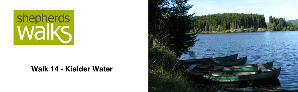

Walk 14 - Kielder Water - Moderate Route
Distance: 8.5 miles
Maps: Explorer OL42
Walking time: 4 hours
Start and Finish point: Hawkhope car park (NY 708883), situated at the northern end of Kielder dam. You access the car park by driving along the top of the dam, which is a great experience to start with. It is a pay and display car park with accessible toilets.
DOWNLOAD the self led walking guide for the Kielder Water walk from here
Summary
Get away from the crowds at Kielder and discover the harsh Northeast shore. This walk combines the little walked shoreline that treats you to some spectacular views of the largest man made lake in Northern Europe.
As this stretch is so inaccessible I guarantee a quiet walk with a sense of isolation which is quite unique.
You then return via the broad forest tracks that have plenty of interesting points of view on the way.
The route is very well way marked and is great underfoot.
Route Details
Leave Hawkhope car park using the path at the top end (large sign saying ‘North Shore Footpath’ and a large marker post saying ‘Lakeside Way).
You follow the main prominent path with a railed fence on your left and the trees on your right.
You are following the Lakeside Way. This multi-purpose path was put in place recently and encircles the whole lake. If you walk the whole path it is 25.3 miles but what a surface to walk on! People perceive it as a flat route but the whole route around the lake climbs (and therefore descends) 1,500 feet. The great thing is now you can walk, run, cycle or push a wheelchair completely around Kielder Reservoir.
Before the Lakeside Way was put in place there was a basic footpath around the lake and the first bridge you come to gives you a great impression of the before and after, with the ‘old’ and ‘new’ bridges next to each other.
You soon reach a sign saying wave chamber, pointing off to the left. The walk continues straight on, but please feel free to visit it and then return back to the main path.
Wave Chamber is a camera obscura, projecting an image of the water on to the floor of a small stone structure. Within the dark interior the walls echo the wave sounds and the floor appears to become liquid. The building takes the form of a drystone beehive on the shoreline with a small door to allow access. Although the interior initially appears very dark, as your eyes adjust to the low light level a moving image of waves on the lake appears on the floor as if by magic.
As you continue along the main lakeside way route you pass another marker post (saying - Kielder Castle – 10 miles).
The path cuts inland a little as you walk round one of the inlets before you reach and cross a bridge, taking you over the Belling Burn.
You continue on, with the reservoir on your left and the forest initially on your right, before the path opens up as you stick to the main path.
This open section of the forest is ideal habitation for roe deer, as they like the sweet picking of young grass. Also the meadow pipit loves this type of scrub. Most of the birds that live around Kielder are summer visitors and migrate to warmer climates during the long Northumbrian winters.
You pass another Kielder Castle marker post before dropping down and crossing over a bridge.
As you come back to following the reservoir, rather than the inlet, you pass a sign pointing off to ‘55/02’ to your left. Again please feel free to visit it and return back to the main lakeside way.
55/02 is a brightly painted steel structure located within a stand of trees at Cock Stoor on the north shore of Kielder Water. The structure's name refers to the latitude and longitude of the site and highlights the importance of the building’s location to its design, where key site lines contribute to its unusual layout and seating orientates visitors towards particular views of the wider lake and into smaller inlets nearby.
As you continue along the walk you pass another signpost for Kielder Castle (now just 8 miles away)
You get a really good outlook onto the reservoir at this point. Tower Knowe visitor centre across the reservoir a little to your left and Leaplish Lodge across and to your right. The reservoir is more than 7 miles (11km) long with a surface area of 1086 hectares and has a shoreline of 27 miles. It stores more than 200,000 million litres of water.
The route then passes inland a little and you pass over another bridge, before the path gradually rises up through the forest as you head toward the main lake itself.
The route then drops steeply back down, with the path in front of you leading to the jetty and Belvedere, but we take a sharp right just before those signs and continue along with the reservoir on your left.
You then gradually rise up and pass another Kielder Castle sign before you reach the next bit of artwork which is called Robin’s Hut.
Robin's Hut is one of a pair of small buildings located on this side of the reservoir. The two buildings, Robin’s Hut and Freya’s Cabin, are linked by the story of Freya & Robin, which tells a tale of the two characters who live by the lake and their efforts to meet up. Robin's Hut is a simple cedar shingle clad open-ended timber structure sited on the more remote north shoreline of Kielder Water.
Find out how the designers' experiences on that day fired their imaginations by reading Robin's story which can be found in the shelter.
As you continue on there is a sign to a ‘vantage point’, which you are more than welcome to visit, but please return and continue along the main path and pass another sign for Kielder castle
As you reach the next vantage point you see a steep track down to it. This is where you leave the main path and turn right up the steep path, climbing away from the reservoir. Before you do this take a few minutes to read the information board and take in this wonderful part of the walk. Plashets Quarry, is the route of the old railway line leading to the old quarry, which is now under water.
Plashet’s Quarry is on a line of ‘Whinstone’ which was quarried here during the construction of the reservoir and was used in the construction of the dam and for shoreline protection blocks called ‘rip rap’.
Pass up the steep Plashet’s incline, which was a self-acting railway, where trolleys full of coal linked Plashet’s quarry above to a railway depot on the now submerged Border Counties railway line.
As you reach the top bear around the barrier before bearing right along the forest track and as the track rises up ignore the track off to your right. Continue straight on along the main track
You pass a lovely, secluded pond away down on your left-hand side before you drop down to a large bridge over the Belling Burn.
As you rise up to a T-junction you bear right. Ignore the large forest track going up to the left as you continue along the main forest track, with the reservoir away to your right hand side.
Just a few hundred yards before you reach a barrier leading back onto the car park you turn right, pass over a small footbridge before the path rises up and takes you back into the car park.
Revised March 2014