
Walk 13 - Hadrian's wall - Moderate Route
Distance: 4 miles (6.4 km)
Maps: Landranger 87 or Explorer OL43
Walking time: 2 hours
Start and Finish point: Steel Rigg car park (NY 751676), situated about a half mile to the North of Once Brewed on the B6318 Newcastle to Haltwhistle road.
DOWNLOAD the self led walking guide for Hadrian's Wall from here.
Summary
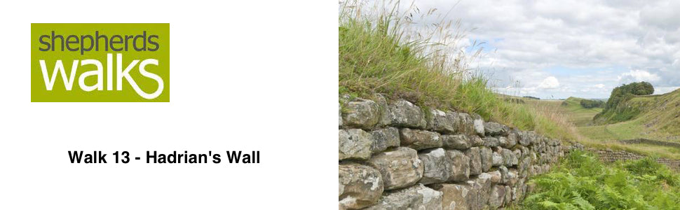
This walk in my opinion covers the finest stretch of the wall.
This superb circular walk passes through some fantastic scenery, which will take your breath away and it makes you realise the strategic importance of the Whin Sill that this section of the Roman Wall is built on, with the peaceful Crag Lough shimmering down below it.
The walk is good under foot and follows the wall for the first half and then returns via a lower route looking back towards the great wall. You get a real feel of what an impressive structure it would have been.
Route Details
The car park itself is built on the Roman wall, which would have been 4.5 metres high at this point. From the Steel Rigg car park go through a small gate (Public Footpath sign, Roman Wall (PF)) leading down to the wall. When you reach it turn left through a small gate (PF marker on it).
As you follow the wall you drop down and rise up steeply onto Peel Crags, crossing over a ladder stile. This part of the wall was excavated between 1909 – 11 by F.G. Simpson.
Keep to the path as you drop down and then cross a wall on a small ladder stile, before rising up on a broad path. On your left hand side you can see the way the wall has degenerated before being reconstructed again in recent years.
You then drop down to your first milecastle (number 39), with the layout clearly visible. Thirty-two men would have manned each milecastle. There would have been barracks, stables, kitchens and stores to serve all the needs of these soldiers. You can visibly see the milecastle is open at both ends. Traders, farmers etc. would have been allowed to pass through the milecastle for a nominal fee.
Pass the single sycamore tree on the wall. This area was used to film a scene on Robin Hood Prince of Thieves, starring Kevin Costner. I am always puzzled how Northumberland was used as a location when Robin Hood makes his way to Nottingham from Dover. I guess you were not supposed to recognise the location, but I did.
Carry on the good path continuing to follow the line of the wall, before you cross over it. At this point you get a very good impression of how the wall would have been. Also the construction techniques can be clearly seen with the two faces of the wall filled with smaller stones in the centre cavity.
Down in the cliffs on your left hand side dropping down to Crag Lough you can see Rowan trees (mountain ash) growing out of the rock face.
Crag Lough is a shallow lake that would have been formed in the Ice Age. Keep an eye open for Swans, Tufted ducks, Coots and Mallards which all nests here.
As you continue you enter a stand of mainly pine trees, with a stone wall now on your right hand side. This is where the old Roman wall would have stood.
You leave the wooded section by a ladder stile and then there are some Alder trees on your left leading down to the lake.
After a short distance you cross a ladder stile on your right and then another one on the opposite side of the track (PF sign Housesteads Fort 1 ½)
Staying with the wall, which is now on your left, you rise up to Hotbank farm, which is now owned by the National Trust. As you are rising up to this farm look over the wall. Here you see a prominent ditch used for the defence of the frontier. This would have been 20 feet wide and 10 feet deep with a flat base of 8 feet wide. The soil taken out from the ditch was built into two mounds each side of the ditch and faced with turf. Causeways were built across these ditches opposite milecastles for access for through traffic.
Just before you reach the ladder stile which is going straight on, turn left over a stone stile next to a gate (PF marker on it), passing to the right of the farm and to a metal gate.
Stay with the main track, passing through a paddock rising gently to a ladder stile. Pass over it and then turn left over a stile next to a gate (PF marker on it).
Cross over the hayfield to a gate on the far side with a gate next to it. Cross the stile (PF sign and arrow). Stick to the path through the next field, as you drop down to a PF signpost directing you right, turning through a double bend you rise up to a ladder stile and a gate. Cross the stile (PF marker on it) and continue to the next stile crossing that with the farm building on your right hand side.
These farm buildings may seem a little remote but they are invaluable in the Northumbrian winters, as they will be filled with supplementary feed stuff to help the livestock on the surrounding ground through the bad weather.
Stick to the path that runs alongside the wall on your right with the spectacular views of the Roman wall away to the South. You get a real feel of what an impressive structure it would have been.
You eventually cross a ladder stile onto the road. Turn left and follow the road back up to the car park.
Revised October 2004
Philippa Money
Hi good summary of the walk but you need to update the section on sycamore gap sadly Philippa Money