
Walk 12 - Dunstanburgh Castle - Moderate Route
Distance: 5.9 miles (9.5 km)
Maps: Explorer 332
Walking time: 2 hours
Start and Finish point: Craster Quarry car park. This is a pay and display car park (Nu256197) where there is toilets and Tourist Information Centre present.
DOWNLOAD the self led walking guide for Dunstanburgh Castle from here.
Summary
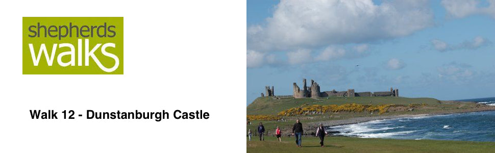
The walk starts in the beautiful fishing village of Craster, famous for it’s kippers, which are produced by the smoking of herring. It takes in one of the finest stretches of coast in the country, passing Dunstanburgh castle and two important sea bird colonies on your way, which provide homes for the seabirds Kittiwake, Fulmar and Shag (extra time should be allocated if you wish to visit the castle ruins).
You then pass inland and return through peaceful countryside, passing a limekiln and an unusual pillbox made from concrete filled sandbags.
The walk is good under foot but strong shoes are recommended.
Route Details
The quarry in which you have parked in once produced the hard and durable quartz-dolerite. This was used for road stone. Since its closure it has been established as a nature reserve under the care of the Northumberland Wildlife Trust.
Come out of the quarry car park, by the Tourist Information building and turn right heading down to Craster, passing the tearooms on your right hand side.
As you reach the harbour bear left and pass in front of the cottages before reaching a gate (public footpath (PF) sign, Dunstanburgh Castle 1 ¼).
Go along the lovely green path with the shoreline on your right. You pass through a small gate and continue on the shore path to a kissing gate. Do not bear off to either the track leading to your right or the one sticking to the coast but instead stay on the main track, which is leading to the castle.
The castle stands on crags of hard, black rock known as Basalt. This is part of the Whin Sill, a great layer of rock that underlies much of Northumberland. The main entrance to the castle is to the South and consists of two drum towers flanking an arched gateway. The gatehouse forms the keep of the castle.
After visiting the castle return to the entrance and turn right immediately and walk on the path that is on the left of the castle. As you reach the seashore again look up to your right at the sea bird colony. These rocks provide homes for the seabirds kittiwake, fulmar and shag. These seabirds, which spend most of the year feeding in the North Sea, return to Dunstanburgh each spring to breed. If you listen closely you may hear the distinctive ‘Kittiwake’ call that gives the bird it’s name. Six hundred pairs of these birds breed here annually, making it the largest sea bird colony in Northumberland.
Staying with the coastline you pass through a kissing gate on to Dunstanburgh Castle golf course. Bear right at the fork. Stick to the path as it goes along the sand dunes. As you go notice the strange folded rock on the beach a few yards along. It is known as Greymare Rock, after it’s shape and colour.
You then pass a pillbox, which is a small-fortified emplacement, made from concrete that was used in the wartime to protect the coast from the threat of invasion.
The bay stretching off into the distance is called Embleton Bay. Sir Ivan Sutherland gave the bay, which includes the golf course, to the National Trust in 1961.
Stick to the path until you reach a second pill box, then as you drop down, turn left on a track which passes through the golf course leading to a small gate onto the road.
Pass through the gate and continue up the road for a short distance before you turn left. Just before the buildings (Public Bridleway sign Dunstanburgh Square 1 mile) pass through a gate.
After a short distance turn left off the road as it doubles back on itself, heading for a gate away from the buildings. Pass through it and onto a concrete surfaced road.
After a while you pass over a cattle grid just before a limekiln on your left-hand side. These kiln furnaces were filled up with coal and limestone and a fire would be lit at the bottom. The lime would then be drawn out when ready. The kiln would be kept going non-stop as the kiln was continuously topped up with fresh fuel and limestone. The lime had many uses. Some of these were to reduce acidity of the soil and improve texture, to mix with sand and water as mortar and to sell to the chemical and iron industries.
Just as you pass the limekiln notice the pillbox on your right which has been made from concrete filled sandbags.
You then drop down to another cattle grid with a fine view of the castle away to your left. Pass through the next gate and go between the farm buildings onto a tarmac road, which bears round to your right.
After the corner turn left through a gate onto a track opposite the houses (PF sign Dunstan 1 ½ miles). Stick to this track which goes down the right hand side of a field next to a hedge, until you reach a wooden gate with a public footpath marker on it. Pass through it and continue on the track to another wooden gate into a grass field (PF marker on gate).
After passing through the gate turn half-right across the field heading just right of the house with the red roof tiles. You pass down to a kissing gate and go through it, turning left along the road.
Stick to the main road as it bears round to your left then turn right back into the car park.
Revised July 2004