
Walk 11 - Hareshaw Linn - Easy Route
Distance: 3 miles (4.8 km)
Maps: Explorer OL42
Walking time: 2 hours
Start and Finish point: Hareshaw Linn National park car park in Bellingham (Ny 840835). From Bellingham Main Street turn up the Redesmouth and West Woodburn road. Immediately after the bridge, opposite the police station and garage turn left. The car park is up on your left.
DOWNLOAD the self led walking guide for Hareshaw Linn from here
Summary
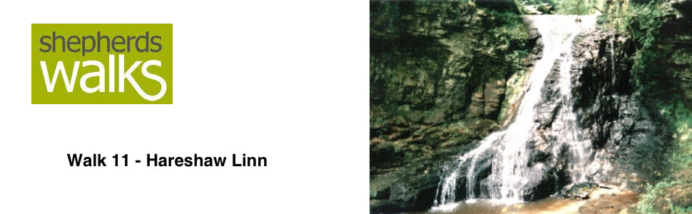
This is a wonderful woodland walk, which follows the Hareshaw Dene up to The Linn, a 30-ft waterfall. (Linn is the old English for waterfall). During the first part of the walk you pass through the spoil heaps of the iron works before entering the woodland section which has been enjoyed by the locals since the end of the 19th century. A wide range of fauna and wildlife is around you all the time, so it is certainly not a walk to be rushed. The walk is mostly good under foot but it can get a little muddy in winter.
Route Details
From the car park continue along the road away from Bellingham, through the gate (Public footpath (PF) sign Hareshaw Linn 1 ½ miles). The row of stone cottages standing on your right-hand side were the old offices of the Hareshaw Iron works that closed in 1848. The foundry produced some of the iron used in the construction of the Newcastle’s high level bridge. Sadly, due to its isolation, the Iron works closed just 14 years before the Border Counties Railway reached Bellingham which surely would have had made it viable.
You soon come to a small kissing gate (PF marker on it). Pass through it and stick to the track as it turns from tarmac to gravel under foot. You rise up gradually, passing a PF marker post. You can either follow the track up to your left or stay on the main one, they both lead to the same place. If you take the left hand option you rise up on top of the old spoil heaps. From here you get a good view of Bellingham’s 9-hole golf course to your left with the pens of the livestock mart in the distance.
Go through the next kissing gate and continue up the track. There is the ruin of the old Iron works dam down on your left. The dam was erected around 1839 principally to supply waterpower for the furnace bellows. The Iron works closed around 1848 and subsequent demolition and redevelopment has removed much of the site. A few of the Iron works buildings have survived as modern dwellings but the dam is perhaps the most vivid reminder of a once extensive industrial landscape.
As you continue you pass a PF marker post and then you rise up to the wood and enter it via a small kissing gate (PF marker on gate).
There is a wonderful view on your left-hand side looking down to the burn in the bottom. You walk on some old cobbles, which were originally laid in the 1890’s with the six bridges to improve access to the waterfall. The path has recently been upgraded but some of the old cobbles can still be seen.
Keep your eyes open for a feast of wildlife. We saw a timid Red squirrel in one of the trees not long after entering the wood and if you are doing the walk in either the early morning or late evening you may catch a glimpse of a Roe deer, when these shy animals are most active. Also look at the wide variety of flora and fauna which has made the area a site of special scientific interest. The woods mainly consist of ash, elm and oak but birch, hazel, blackthorn and willow also are present. There is a wide variety of fungi growing on the wind blown timber lying on the floor of the wood.
You rise up to a lovely-secluded spot with a bench before you drop down to the first bridge crossing the burn. If you are doing this walk in late spring or early summer you will get the wonderful aroma of wild garlic which often dominates this habitat after crossing the first bridge.
As you walk up the left bank you see your first waterfall dropping down about three metres to a deep pool in the bottom and then you continue to the next bridge sticking to the bank of the burn.
You then continue crossing the bridges as you rise, with the noise of the burn getting greater as you go further up the valley. The birdsong is now drowned by the noise of the running water but they are still present, attracted by the shelter and the abundance of food available to them. Keep your eyes open for blackbirds, blue tits, great tits, grey wagtails, song thrushes, sparrow hawks and the great Tawny owl.
You will eventually come to a thirty-metre walkway that is built on the rock face. On the opposite side of the valley you can see the trees growing out of the rock face before you drop down to a lovely bridge with a shallow pool below and under it. If it is a hot day this is a brilliant spot to see the insect life on the water surface.
You then rise up to the waterfall with the cliffs overhanging on the right and the roar of the water in the distance. Drop down to the waterfall where the path comes to the end beneath the overhanging cliff. Ahead of you are the steep wet banks each side of the waterfall covered in mosses. The erosion of the cliff faces around the plunge pool shows the ferocity of the water.
Progress beyond Hareshaw Linn is not possible, so you must return retracing your steps down the valley.
Revised August 2000
Jon Monks, Shepherds Walks
Many thanks for your question.
It is a 3 mile round trip walk i.e. 1.5 miles there and 1.5 miles back.
I hope this helps.
Jon
Sharon Shortland
It says the walk is 3 miles, is this a round trop or is it 6 miles round trip please.