
Walk 1 - Whitton Hillhead - Moderate Route
Distance: 4.8 miles (7.78 km)
Maps: Explorer OL42
Walking time: 2 ½ hours
Start and Finish point: Rothbury. Cowhaugh car park (NU 057015) situated next to the river Coquet. If you are entering Rothbury on the B6342 from the south (Cambo direction), turn left just before you cross the bridge as you approach Rothbury village centre. The car park is situated on your right.
DOWNLOAD THE WALKING GUIDE FOR WHILLTON HILLHEAD FROM HERE
Summary
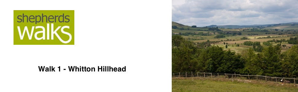
This is a nice gentle walk that climbs up to 212 metres (700 ft) at Whitton Hillhead where beautiful views of the Simonside Hills can be seen.
Before you reach Whitton Hillhead you pass Sharp’s Folly which was built for astronomical research in the 18th century. As you continue on from there you are presented with some picturesque views looking down on the small town of Rothbury and the striking Simonside Hills rising above you.
Route Details
From the car park go out of the entrance you drove in through, turn left and walk up the left-hand side of the road on the pavement with the river on your left leading towards the road bridge.
This bridge was originally constructed in the fifteenth century, with three arches. The nearest arch to you was added in 1759 as the river moved southwards. The changes caused by the movement of the river are quite obvious when you see the area of flat ground on the far side of the river.
Just as you reach the road bridge ignore the road going off to your right, but cross the road and walk up the steps which are located to the right of the bungalow, situated directly opposite the bridge.
After you reach the top of the 74 steps turn right along the road and walk along it, with the houses on your left and the view of Rothbury away to your right. The Church Tower of All Saints Church stands proudly with the clock on its tower.
All Saints Church is built on the site of a much larger Saxon church. The Church was ‘Victorionized’ and therefore mostly rebuilt in 1850. The only portion of the original thirteenth century building is the chancel, the east wall of the south transept and the lofty chancel arch. The base of the font is made from the foot of a Saxon cross.
As you reach the end of the road, ignore the road on your right doubling back on itself, but continue straight on as the road turns into a track and walk up to a small kissing gate.
Pass through it and walk directly up the field in front of you, walking in the direction of the public footpath signpost indicating Whitton ¼.
On your left is a wooden garden fence with a ‘barb guard’ incorporated into it. Cattle seem to like to have a chew at all things wood so hopefully the single strand of barbed wire that protrudes from the fence will keep them away from this garden fence.
You climb steeply up the field and as you reach the brow of the hill you can see a tall post located at the stile, which is between the stone buildings on its right and the lower level wooden buildings, which are stable blocks, on its left. Upon reaching the wooden kissing gate pass through it, follow the path as it turns left and then right leading in to a car park. Pass through the car park on to the road.
Turn right along the road and after about 50 yards turn left off the road along a track (signpost - Public Bridleway, Whitton Hillhead 1 ¼).
After a little while another track joins yours from the right, but you just continue on as you gradually rise to Sharp’s Folly on your right.
Sharp’s folly was erected by Rev. Dr Thomas Sharp who was the son of the Archbishop of York. Sharp lived at the Pele Tower in Whitton and was the Rector of Rothbury 1720-1758. Being something of an eccentric he came up with the erection of a folly as an early job-creation scheme for the locals. It did, however, have the added practical use as an observatory for the doctor's astronomical studies. It is the oldest Folly in the county and a listed building.
Continue on along the track passing a small number of caravans on your right.
Down to your right you can see the basketball court and children’s play area. Below this you may just be able to pick out the caravan park.
This small family caravan park is set within 13 acres of grounds and caters for both static and touring caravans as well as tents. It is open during the spring and summer months of the year.
Continue along the track, ignoring the footpath going off through a metal gate on your left.
As you continue on you can see that the hawthorn hedge on either side of the track has been ‘laid’, in the past. This has been done by taking a small cut out of the bottom of each plant and ‘lying it down’, to run parallel to the ground. This is then woven around a number of small posts to keep it in position. As you can see the new growth has grown up from this making a good dense field boundary.
You pass a small plantation on your left, immediately after this there is a track going off to your left. Ignore this and continue straight on as you rise up a little with a hedge either side of you.
As you continue on you lose the hedge either side and it is replaced with a fence. Cross the cattle grid and the path opens up as you have grass fields either side of you.
This ground has been improved in the past. If you look across to your left at the ground at the same level you can see that it is rough, covered in bracken and is true upland ground. That is what these fields would have been like before man cultivated them and sowed more productive grass seeds. This would have been done periodically as newer and more productive seed mixtures became available to the farmer so that the ground could be made more productive.
Continue on along the track, crossing another cattle grid.
Away to your left, the far-left peak of the long ridge, whose lower slopes are clad in heather, is called Dove Crag (1300 feet).
Continue on, passing a gate into Curlew Cottage on your right, shortly before you cross another cattle grid.
The hedge on your left is a superb example of what happens if it is not ‘laid’. It stands tall making it totally un-stock proof.
Pass Whitton Hillhead farmhouse on your right. As the track passes around to the right you can see a ‘Dutch barn’ located behind the house. These large open-fronted barns are purpose-built to store hay and straw. In the past when these two crops were baled in small square bales they would be stacked inside these barns, standing flush with the open sides. These open sides were incorporated into the design so that bale ‘elevators’ could be placed into the barns to lift the bales high up as the barn became filled. In more recent years with the advent of the ‘round bale’ and ‘large square bale’ these barns have still been used to store these bales as they give easy access to the modern machinery used to stack them.
Pass through a large metal gate straight in front of you and turn left through a wooden gate, located just before a large farm shed (Bridleway marker on gate).
This large shed will be used to house the livestock during the winter months. This is done both to shelter them from the weather and to stop the livestock from ‘poaching’ the wet fields. In bad weather ‘poaching’ is caused when the livestock all shelter together and damage the sodden pasture.
Continue along the path and follow the fence on your left and after a short while a ‘barb guard’ joins you on your right, needed to keep the cattle out of the area you are walking through.
In front of you, slightly to your left, rising above the forest you get a lovely view of the sandstone crags situated below Simonside itself.
The Simonside Hills rise up to 1500 feet. The sandstone crags, situated below the summit of Simonside, are very famous and are mentioned in “The Climbers Journal” dated 1902! As such they were the first crags, in Northumberland, to be so recognised and there are more than one hundred different routes up the rock face.
You reach and pass through a large metal gate (Bridleway marker on gate) and continue on following the fence on your left.
You reach and pass through a large wooden gate. Turn right through 90 degrees (marker post) and follow the path down the right-hand side of the field, with a number of trees to the far side of the fence you are following also on your right.
As you drop down you can see the small village of Thropton in front of you, at the far side of the meandering river.
Thropton is a small parish on the north bank of the river Coquet in central Northumberland, upstream from Rothbury. The village of Thropton was first recorded in 1249. Maps from 1620 show that the modern village is on the same site as an earlier settlement. The village is believed to have been the site of a set of medieval gallows, which were probably built there in the early 13th century.
Continue down with the fence on your right as it bends through 90 degrees to the left. You pass a small marker post and continue down to and cross a stile located to the right of a large gate (Public Footpath arrow on stile).
Follow the path that is running parallel to the fence on your right. As the fence bends off through 90 degrees to your right you continue straight on staying on the edge of the higher ground with the ground dropping away to your left into a small valley. Continue along and you reach a track, bear left along it, just before you reach some trees situated down below.
Follow the track as it rises up, passing a diverted public footpath post and continue on towards the corner of a fence. Bear right along it down to a gate and pass through it. Turn left along the road and walk along it, passing a small bungalow on your right before passing a large farm on your left called West Newtown.
Continue along the road, passing a road going up to your left (road sign – Great Tosson ½, Lordenshaws 2 ½). Follow the road around to the right then at the next bend you turn right (road sign – Tosson Mill ¼), passing a public footpath sign (Rothbury 1 ½) on your left and a house on your right with a large millstone built into the wall.
A little way down this single-track road you pass a Victorian post box built into the wall before passing the old Tosson Mill on your right. This is the site of a water-driven woollen mill built in the early 1800s by Thompson of Newtown.
After the last house on your right the road turns into a track with a stone wall on your left-hand side. Follow the track as it turns through 90 degrees to the right and you walk down a fence lined track with a hawthorn hedge on your right in front of the fence.
Pass through the small gate, located to the right of a large metal gate and continue along the track.
You pass through the small gate taking you on to the footbridge. Pass over the bridge.
This is called Lady Bridge, believed to have got its name as it was a dry route for ladies going to the old mill, which we passed a little earlier in the walk. The only other way to cross the river was by stepping stones.
Immediately after the footbridge bear slightly to your right and pass through a kissing gate and walk in the direction of the Public Footpath sign (Rothbury 1) through the next field. The stile you are heading for is located in the same line as the two electricity poles, which are next to each other in the distance.
Cross the stile and keep in the same direction, crossing a small footbridge and up to a marker post. Turn right along the path and follow it with the ground rising up to your left. Cross the small footbridge and continue along the prominent path, bearing right at a bridleway marker post and continue on with the river down to your right and the road up to your left.
You reach and pass through a small wooden gate (Public Bridleway arrow) and continue on.
Pass the access bridge for the golf course on your right and walk directly across the road, passing a marker post and continue along the path with the river on your right.
On the opposite side of the river is the golf course. This originally was a steeplechase course. The first official meeting was held on April 28th, 1762, and the final one was on April 10th, 1965. They would place a removable bridge spanning the river Coquet especially for race days. The horses mainly travelled to Rothbury by railway and then were stabled all over the area.
The Duke of Northumberland was the steward at the last meeting, when the races had to come to an end due to the withdrawal of the Horserace Betting Levy Board’s financial contribution. A dozen other small meetings were closed at the same time for the same reason.
Carry on along the riverbank ignoring all the steps and paths leading up to your left and you eventually reach and pass a number of large buildings up on your left-hand side.
The first of these is Rothbury House. This was originally opened in 1789 as the County Hotel to cater for the visitors. Now it is owned and managed as a convalescent home for the Royal Air Forces Association.
In years gone by there were very grand hotels in Rothbury, as it was very popular in the early 1900’s and considered a healthy place to go on holiday. Most people would travel there by rail but on Saturday 13th September 1952 the railway was finally closed to passengers.
As you follow the river you eventually go past the playground and then cross the footbridge on your right back to the car park.
Ginette Murphy
Fantastic resource, thank you.
Any chance of you giving the GPX as well?
Best wishes ,
Ginette