
Walk 2 - Cragside Carriageway Drive - Moderate Route
Distance: 5.5 miles
Maps: Explorer maps OL42 and 332
Walking time: 3 hours
Start and Finish point: Old Tourist Information Centre, Rothbury
Please park in the Cowhaugh car park in Rothbury, which is situated next to the river Coquet. This is a pay and display car park. Directions - If you are entering Rothbury on the B6342 from the South (Cambo direction), turn left just before you cross the bridge as you approach Rothbury village centre. The car park is on your right hand side. The grid reference of the car park is - NU 057015
From the car park cross the pedestrian bridge and turn right along the river bank. Take the first path on your left, taking you up some steps. When you reach the top of the path continue walking in the same direction, passing the church on your right. The old Tourist Information centre (The Coquetdale Centre) is the second building after the church.
DOWNLOAD THE CRAGSIDE CARRIAGEWAY DRIVE WALKING GUIDE FROM HERE
Summary
This superb walk explores one of the prettiest areas in the Coquet Valley.
Initially the walk takes you north of Rothbury, with great views of the old race course before continuing up the old Carriageway Drive.
From here you get great views across the valley to the Simonside Hills.
A great walk. Strong shoes are essential and don’t forget your waterproofs.
Route Details
From Coquetdale Centre (the home of Shepherds Walks) walk up the left hand side of the high street, passing the vets on your left with the shops away on your right (opposite side of the road).
As you reach the Police Station and Coquet Arts Centre cross the road to the bus stop sign and bear left just in front of the bus stop sign and follow the little path up to the top road and turn left along it.
King John gave Rothbury its charter as a market town when he visited it in 1205. For a couple of centuries the Border Reivers kept things lively in the valley with thousands of sheep, cattle and horses stolen from both sides of the border. In the early 19th century Rothbury was a poor two street affair, with mostly stone cottages and houses, thatched with heather from the surrounding hills. It had lots of public houses, several small shops and of course a Parish Church. All the roads were earth surfaced.
Take the next road on your right (just before Catholic Church); ignore the footpaths going off to the right as you climb up the steep road.
As you rise up you are treated to some great views of the golf course away to your left.
The golf course is located on the flat ‘haugh’ ground that in the past was the location of the old Rothbury race course. They used to put a temporary bridge across the river to get all the horses and spectators across.
At the top of the hill turn right along ‘Hillside East’ and then take the first left along ‘Pennystane Lane’.
Follow the road as it bends around to the right and winds its way up. It turns into a track before you reach and pass through a large wooden gate.
Continue along the track with a large wall initially on your left as you rise up before dropping down.
You pass a gate on your left (don’t go through it) on which there is a sign to ‘Gimmerknowe’ .
This surely has to be the best named cottage in Northumberland. Gimmer is a two year old sheep and knowe is a small hill. This therefore will be the paddock next to the shepherd’s cottage that the ‘first time lambers’ would be put in for lambing time enabling the shepherd to keep a close eye on them.
Continue along the track on which you were previously as it passes through a wooded section before rising up and passing a remote house on your left.
The track bends around to the right and you start to follow a wall on your left.
Stone walls are actually two separate walls held together with ‘through stones’ which tie the two walls together. The cavity formed is filled in with small stones and then capped off with ‘coping stones’ to make the whole wall weather tight.
Ignore the gate on your left but continue following the path as you lose the wall on your left.
After a little while you see a steep narrow, indistinct path going up to your right (just before a large tree), follow this up to the carriageway, which is a large track. If you miss the steep path don’t worry the path you are following eventually bears to the right and eventually joins the carriageway drive further up.
Once you reach the carriageway drive turn right along it.
Simonside can be seen on the opposite side of the valley. The distinctive flat top is very easily recognisable and as it stands away from the true ‘Cheviots’ it is very well known in the walking world.
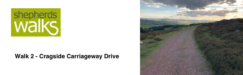
The Carriageway Drive is reasonably level as it was made for the horse and carriages era, it winds around so that it keeps to level ground.
Continue along the drive for some distance.
As the track turns sharply to the left there is tall warning sign regarding the overhead wires, a little way before you reach a communication mast. Bear right along the rough footpath (please note you are going to the viewpoint and then will be returning back to this point), which leads to a stone cairn overlooking Rothbury. Here you are treated to some of the finest views of Rothbury.
The car park on the far side of the river can be easily picked out and all Saints Church (the large church next to Shepherds Walks) can also be seen. Away to the left you can see the wooded hillside of Cragside and you may be able to pick out Cragside House at certain times of the year.
Retrace your steps back to the carriageway and turn right along it, passing the communication towers on your right.
You then reach and pass through a small kissing gate located to the right of a large wooden gate as you enter the woods.
The path then gradually rises up as you pass over ‘Addycombe Hill’. Ignore the footpath going off to your right but stay to the main carriageway which narrows a little in a few places.
As you drop down you pass through a few hairpin bends. Stay on the main track ignoring all other paths. Eventually the trees stop on your right and you follow a fence, with a field the far side of it.
From here you are again treated to another fine view of Rothbury, but this time from a very different angle.
As you continue on you reach a large tall marker post with a red band around the top, this post is marking the route of the gas main into Rothbury.
At this post turn through the kissing gate on your right and follow the fence on your left, passing down through the field.
Pass through the next kissing gate and follow the path down to a small wooden gate which then drops down some steps to the track, which you turn right along it.
Continue along the track and after a little while it turns to tarmac under foot and you start to get some houses up to your right.
Take the footpath on your left (Public Footpath – Rothbury ¼ ) and follow the gravelled fence lined path as it drops down steeply to Rothbury village. At the bottom you pass through a small kissing gate and after passing a couple of bungalows on your left you reach the road. Turn right along it.
As you walk down the road you have Addycombe Cottages on your left which are the old workers cottages for the staff on Cragside Estate.
The road drops steeply and bears around to the left before reaching the T-junction.
Turn right here passing the Queens Head Hotel on your right, as you reach Otterburn Mill, also on your right, cross the road and continue on past the Newcastle Hotel.
Turn left after the Newcastle Hotel and it will bring you back to the start of the walk