
Trig points - what are they for?
A trig point, also known as a triangulation station, trigonometrical station, or trig pillar, is a physical marker or point of reference used in geodetic surveying and mapping.
These markers are typically found on hilltops, mountaintops, and other elevated locations, and they serve as crucial reference points for determining accurate positions and elevations on maps.
Trig points have a specific historical significance and have played a vital role in the development of mapping and surveying techniques.
I also found this superb video that helps us understand how a trig points was used the map countries, including the UK (sadly I was unable to embed it within the article, but) - watch the video here on YouTube
Brief history of trig points:
1. Origin and Historical Significance:
- Trig points have their origins in the early days of geodetic surveying, which aimed to accurately measure and map the Earth's surface. The use of trig points became widespread in the 19th century.
2. Triangulation Method:
- Trig points are strategically placed across a region to create a network of interconnected triangles. Surveyors would measure the angles and distances between these points, a technique known as triangulation, to determine the precise locations of features on the Earth's surface.
3. Mapping and Cartography:
- The data collected from triangulation surveys were used to create accurate topographic maps, which were essential for various purposes, including land use planning, construction, navigation, and military planning.
4. Trig Point Construction:
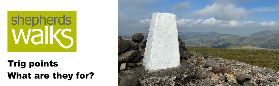
- Trig points are often constructed of durable materials like concrete, stone, or metal to withstand weather and the test of time. They typically have a distinctive pyramid shape, with a metal plate or disc on the top that can be used for surveying instruments.
5. Decline in Use:
- With advancements in technology, particularly the use of GPS (Global Positioning System), the traditional method of triangulation and the reliance on physical trig points have diminished. GPS allows for highly accurate positioning without the need for an extensive network of physical markers.
6. Cultural and Historical Significance:
- Trig points often hold cultural and historical significance in many countries. They are sometimes considered landmarks and points of interest for hikers and outdoor enthusiasts. In some regions, trig points have been preserved and maintained as historical monuments.
7. Preservation and Restoration:
- Some organizations and individuals are involved in preserving and restoring trig points to ensure they continue to serve as historical and geodetic landmarks. These efforts help maintain the historical and cultural value of trig points.
In summary, trig points are markers used in geodetic surveying to establish accurate positions and elevations on maps. They played a crucial role in the development of mapping and surveying techniques in the past, even though their significance has declined in the era of modern technology. Despite this, trig points are still appreciated for their historical and cultural value.
GJ
“Trig points are strategically placed across a region to create a network of interconnected triangles. Surveyors would measure the angles and distances between these points, a technique known as triangulation, to determine the precise locations of features on the Earth’s surface.”
Stricter truth is even more interesting. Measuring lengths, especially between hills only became a practical proposition from about 1960, using microwave, and a practical proposition, for general use, with the adoption of light beams, from about 1975. Two lenghts were accurately measured over flat ground: The “Base Line” was measured in bays, initially using rods, but then steel bands, which were compensated for tension, and temperature. This was a careful, slow, labour intensive process. The base line was extended, to give a longer base line, but by measuring angles only. A second “Check Base Line” was worked into the opposite extreme of the triangulation scheme. All triangles within the scheme comprise measured angles only. The base line measurement propagated through the scheme, and is hopefully confirmed (within tolerence) when the check base is measured!
The only length measured at the trig was the height of the instrument axis above the bench mark.
Steve
👍