
Walk 33 - Amble and Hauxley - Moderate Route
Distance: 5 miles (8 km)
Maps: Explorer Map 332
Walking time: 3 hours
Start: Amble Tourist Information Centre. As you enter Amble follow the brown signs to Amble Tourist Information Centre. There is a free car park next to the building or directly opposite (grid ref - NU266046).
DOWLOAD a PDF of this walk with a map from here.
Summary
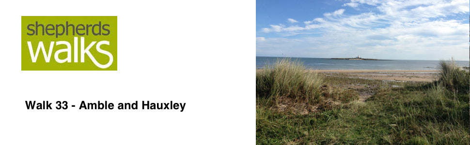
This lovely coastal walk takes in a great section of coastline south of Amble. Initially you are treated to some spectacular views of Coquet Island before reaching and skirting around Hauxley Nature reserve.
The return part of the walk passes through some lovely farmland as you make your way back to Amble.
Route Details.
From the Tourist Information Centre cross the Market Square.
Pass the sundial in the market square, which is said to be one of the largest in Europe, and then walk along the road with Spurrellis and then the HM Coastguard office both on your left. Continue down the road and turn left just in front of the Keyside Café. Continue your walk with the small harbour on your left and pass Keyside Seafoods on your right.
As you walk around the corner you get a lovely view back up the River Coquet to Warkworth, with the castle standing tall.
Before you reach the white structure on the keyside bear right and head towards the barriers. Pass to the side of them and walk along the road, with the houses on your right and the sea on your left.
When you reach the T junction turn left (brown sign – paddling pool, play area and the links) and walk up the road with the houses on your right.
Where you reach a fork bear left off the road along the pedestrian walkway and continue on with the blue railings on your left.
As you reach the top turn right and pass up some steps and on into the park, follow the path as it drops down with the small rock face on your left. Turn left just in front of the paddling pool and go up the ramp with the railings, which takes you up and drops you down on the far side of the sea wall.
Continue on with the paddling pools on your right and the sea on your left, and Coquet Island clearly visible.
Coquet Island is an RSPB reserve about one mile off Amble and is home to a large colony of nesting seabirds such as the Roseate Tern, one of our rarest nesting seabirds, with the island holding 90 per cent of the UK's Roseate Tern population. Several thousand nesting Sandwich, Arctic and Common Terns accompany the Roseates in May, June and July, and thousands of Puffins occupy the main part of the island. Coquet Island has been occupied since the 7th Century, initially as a monastic cell, later a lighthouse station and now by the RSPB wardens, who live on the island through the spring and summer.
At the end of the sea wall keep walking in the same direction passing a way marker post on your right (with faded way markers on it) as you climb up through the sand dunes and it brings you out on a grass field.
Continue walk along the edge of the grass field with the sand dunes on your left and the grass field on your right. At the end of the field you reach and cross a track and follow the path with a wall running on your right.
As the wall turns through 90 degrees to the right you follow it and then you turn left at the Northumberland Coastal Path way marker. Follow the Northumberland Coastal Path with the sand dunes on your left.
The Northumberland Coastal Path is 67 miles in length and starts in Cresswell in the South and passes all the way up to Berwick upon Tweed. A stunning long distance path and certainly worth exploring on foot or walk a 26 mile section of the path in May every year as part of the Northumberland Coastal Challenge walk.
You drop down and cross a narrow road leading into a car park and continue on in the same direction as you follow the path opposite rising up through the sand dunes.
Continue on passing to the right of a white house and after a short while you reach and cross over a gravel track leading to the house. Continue on, following the prominent path.
A little way on you reach and bear right along a gravely path. Continue on as you pass through the sand dunes with the road away to your right with the caravan site the far side of it.
If you wish to at this point you can drop down onto the beach (if the tide is out) and walk along the beach, alternatively you can continue to follow the path through the dunes. Exit the beach through the prominent opening through the dunes, just before the beach becomes rocky.
You eventually reach a car park. Walk through the car park and turn left along the road following the grass path that runs along the side of the road.
The road turns steeply around to the right and you continue along the road as you pass some houses on the left.
As you reach the telephone box and bus stop turn left (road sign – Low Hauxley) and walk along the road. At the next junction take the middle track (Public Bridleway – Togston Links) and you pass some cottages on your right. Continue along the track passing a large yellow house.
You then reach and pass a large sign saying Druridge Bay Country Park. Just after the sign turn right up a path and pass through a small gate with a ‘Northumberland Wildlife Trust nature reserve’ sign on it. Continue up the tree lined path with a caravan site on your right.
When you reach the top of the track turn right and walk down the track.
Behind you is Hauxley Nature Reserve, which is well worth a visit in its own right. The reserve was created from former mining works and is owned and run by Northumberland Wildlife Trust.
As you reach the junction keep walking in the same direction ignoring the road going off to your right and as you continue on you start passing over a number of speed humps until you reach the main road.
Turn left along the main road and walk along it. After a short distance you enter High Hauxley. Just before you enter the 30 mph speed limit where there is a sharp left hand corner you need to turn right (Public Footpath – Amble 1 ½ ). You can either go through the white gate and onto a brown gate or follow the track up the right hand side, they both lead to the same place. Here you need to turn immediately to your left and walk on with a field on your right and wall on your left for a few hundred yards before you reach and pass a house.
As you continue on the path cuts through the old boundary and then continue on in the same direction, passing some trees on your right. The path turns 90 degrees to the left and continues on along the edge of the field.
After a short while the path cuts through the field boundary and continue walking in the same direction as you head back towards Amble.
Just as you reach another clump of trees you turn left and pass along the prominent path with the fence on your right and the field on your left before you reach and cross over a stile.
Continue walking in the same direction and after a few hundred yards you reach and pass through a kissing gate on your right and follow the path that is heading towards the caravan site and some houses in the distance.
As you reach the grass and then the road keep walking in the same direction with the caravan site on your right and the houses on your left.
You reach and pass the Radcliffe Club on your right. After the club you have a field on your right. Turn right onto the field and walk across it heading for the bottom edge where the path exits, with the trees on its right and the houses on its left.
After leaving the field your turn left along the road and pass Amble East Cemetery on your right. Burials began in Amble East cemetery in 1878. When it became clear that the cemetery was filling up and could not be extended, Amble West Cemetery was consecrated and burials began there in 1905.
As you continue on you pass the school on your left and continue back into the town passing the Co-op on your right and continue on sticking to that main road ignoring all roads leading from it.
You pass Trinity Methodist Church on your left and the Post Office on your right. Just after this you turn right down Henderson Street and as the road bears around to the right you bear left along a footpath with a house on your right with a ‘no ball games’ sign on the end of it.
As you rise up cross straight over walking in the same direction. You pass a house on your left as you head towards a gable end of another house. Continue on in the same direction to the Market Square and turn left through it, to return to the Tourist Information Centre.