
Walk 3 - Simonside - Difficult Route
Distance: 9 miles (13 km)
Maps: Explorer OL42
Walking time: 5 hours
Start and Finish point: Rothbury. Cowhaugh car park (Nu 057015) situated next to river Coquet. If you are entering Rothbury on the B6342 from the South (Cambo direction), turn left just before you cross the bridge as you approach Rothbury village centre.
DOWNLOAD THE WALKING GUIDE FOR SIMONSIDE FROM HERE.
Summary
This is a pleasant walk suitable for the experienced walker. Strong shoes are required and waterproofs essential as the weather can soon change on the high ridges of Simonside.
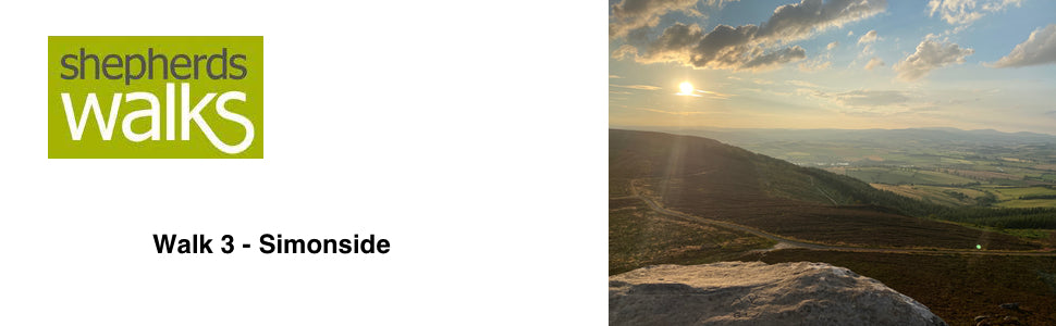
The walk begins on the beautiful Garleigh moors and then gently climbs to an altitude of 429 metres (1500 feet) at the summit of Simonside. From here you will see what I think are some of the most breathtaking views of Northumberland, with the Cheviots away to the north and Fontburn Reservoir to the south. On a clear day the line of the coast can clearly be followed.
The walk ends by following the river Coquet as it winds its way into Rothbury.
Route Details
From the car park go back to the entrance you drove in through and turn left, walking along the footpath with the river on your left.
Ignore the road going off to your right and immediately after it turn right, crossing the road and pass up the large number of steps that are located directly opposite the road bridge.
Upon reaching the road at the top of the steps turn right and follow it with the houses on your left. As the road doubles back on itself, going down to your right you continue straight on. The road turns into a track and passes up to a kissing gate, leading in to a field.
Pass through the kissing gate and walk in the direction of the public footpath signpost for ‘Whitton ¼’. As you climb steeply through the middle of the field and you reach the brow of the hill, you will see a tall post, situated where the stile is. The stile is located with the stone buildings on its right and the lower roofed buildings on its left.
Cross the stile and follow the path, leading on to the car park. Pass directly across the car park on to the road and turn right.
After about 50 yards down the road, turn left off it on to a track (signpost – Public Bridleway, Whitton Hillhead 1 ¼). Continue along the track ignoring the private drive going off to your left and the track going off to your right as you rise up slowly to Sharp’s Folly.
Sharp’s Folly was erected by the Rev. Dr Thomas Sharpe. He was the rector of Rothbury 1720–1758 and it was built for the Archdeacon, who was interested in astrology. It is the oldest Folly in the County and a listed building.
Continue along the track. In front of you is a striking ridge, with rocky outcrops below it in places. This is what you will be walking along a little later in the walk.
After a little while you reach two metal gates on your left. You pass through the second of these gates (signpost - Public Footpath). Walk along the edge of the field following the fence on your left.
These flat fields you are walking through are in striking contrast to the unimproved hill ground in front of you. These fields would have been cultivated and re-seeded over generations, therefore making them suitable for modern machinery to work on, so that both silage and hay can be made in these fields to feed the animals over the winter months.
Continue to follow the fence on your left as you drop down. As you reach the lowest point on the path you cross an old field boundary. This is distinguishable by not only the old stone gatepost still standing, but also the small rise in the field with stones just poking through the surface. New boundaries are usually placed adjoining the old ones, so that wooden fence posts can be driven into the ground easier.
Continue on as you rise up to the stile and cross it taking you on to the hill ground.
Follow the path as it drops down just to the left of a tree and cross the small burn (Whitton Burn), follow the prominent path as it climbs, bearing slightly to your right, passing the corner of an unfenced plantation on your right.
Continue on as the path follows an old broken down wall, just visible by a small rise in the ground on your left as you climb up to a stile located on the horizon, where the wall and fence meet.
Cross the stile taking you over the fence line and follow the path as it goes off slightly to your right, passing a number of marker posts, before reaching another stile taking you on to the heather clad ground.
Cross the stile and rise up on the well-trodden path up to a marker post. At the marker post ignore the arrow on it, but turn left on the prominent path and continue on heading for a tall post which is situated in the distance at a junction where a number of fences meet.
Upon reaching the tall post bear off to your right following the track which follows a sod-cast on your right, leaving the fence on your left. Continue on with the ground rising up to your right. Away to your left situated just to the left of a plantation you have Lordenshaws farm.
After a little while the track you are following bears off to your left, away from the sod cast, skirting to the left of the ground rising up away from you. Just as you go round the corner you can see the car park in the distance that we are heading for.
Just as you reach the car park on the prominent path you pass a small marker post.
Cross directly across the car park and leave it through the entry/exit, taking you on to the single-track road.
Walk directly across the road and continue on up the prominent path in front of you (signpost – Public Footpath, Spylaw 1 ¼, Coquet Cairn 2 ½). You continue climbing up the path passing a marker post, continuing straight on, ignoring the unofficial path going off to your right. Upon reaching the next marker post a few yards up you turn right, following a broken down wall on your right. Continue to climb, passing another marker post on your left.
The path you are following has left a scar on the landscape due to the erosion that has taken place. It is one of the few places in Northumberland where this kind of erosion has happened.
You climb up to your first peak, ‘The Beacon’ (360 metres) with its prominent cairn. If you look over to the east on a clear day the coast can be clearly seen.
Continue on the well-worn path, running along the ridge with the forest down to your right and you pass a cairn before you reach and pass over a ladder stile taking you over a fence line.
Follow the prominent path in front of you, ignoring the path going off to your right, as you climb up steeply. Just before you reach the summit ignore the path going off to your right, which is signposted in the opposite direction as the ‘red walk’.
You rise up to the spectacular Dove Crag (393 metres), with a striking prehistoric burial cairn up to your left and a rocky crag on your right.
Rothbury can be clearly seen down below. One of the striking features of Rothbury, which can be seen from a number of directions, is the small hedge lined fields surrounding the town. Sadly these fields are not farmed individually by locals as originally intended, as mass food production has made them uneconomic and therefore redundant.
Continue on the prominent path that skirts across the top of the crags before passing over to your left on to the ridge. After a little while the path starts to climb a little and you have Old Stell Crag, a rocky outcrop away to your left and to your right in the distance you can see the rounded summits of the Cheviot Hills.
The path slowly rises up to the prominent cairn, which is situated at the top of the Simonside Crags. From here you are treated to some spectacular views of the lower-lying ground.
Rothbury is away to your right and the small hamlet of Thropton is in front of you, on the far side of the forest. The even smaller hamlet of Snitter, which is on the ground that rises up behind Thropton can be clearly seen.
Most of the parish of Snitter is given to agriculture and it is because of this that most of the sites of any historical importance have been found. A Neolithic stone axe is the earliest piece of evidence of human activity in the parish. This was a time when the first farmers began to emerge and the axe could have been used to fell trees in preparing fields.
The sandstone crags, situated below the summit of Simonside, are very famous and are mentioned in “The Climbers Journal” dated 1902. As such they were the first crags, in Northumberland, to be recognised and there are more than one hundred different routes up the rock face.
Follow the path that runs across the top of the crags and upon reaching a post (indicating the red walk coming from the opposite direction) you turn right on the prominent path as it drops down very steeply to the corner of the forest.
At the bottom, walk on to the main forest track and bear left along it, so that the forest is on your left, and pass the orange arrow (indicating Forestry Commission orange trail) on a marker post.
After just over 100 yards turn right (public footpath marker post) down a path, leaving the main forest track. Follow the prominent path down through the heather, as you walk away from the track. You pass a public footpath marker post and ignore the permissive path going off to your right and continue on as you enter the forest.
The well-worn path drops down through the forest. Upon reaching the forest track cross it (as indicated on the marker posts) on to another path and continue on, passing a marker post (with an orange arrow on it).
The path continues to drop down passing through a broken down wall.
These derelict walls make you realise that all this land would have been farmed before it was planted. It would have been grazed with hefted hill-sheep before the Forestry Commission bought the land.
Eventually you reach a forest track. Turn right along it (public footpath marker post) and after about 30 yards you turn left off the track and pass down to and through a small wooden gate taking you out of the forest (yellow arrow on gate).
Follow the prominent path as it runs parallel to the forest on your right.
Away to your left the ground drops down steeply to a flatter area of the field. At the bottom of the slope it is very obvious where the field has been improved. The gradient on the bank has made it impossible to improve the pasture, due to its inaccessibility for farm machinery.
You reach and cross a ladder stile, which is situated to the right of a large metal gate. Continue on the path with the ground rising up to your right to the forest.
Upon reaching a stile, which is situated to the left of a large wooden gate, cross it (public footpath arrow on stile). Continue on the prominent path and follow the wall, which turns to your right through 90 degrees. Follow the wall on your right, with the forest the far side of it as you drop down to a corner in the wood.
At this corner you have a permissive path to Tosson Burgh Hill Fort going to your left. Don’t follow this but continue straight on, passing over the permissive path and walk out into the field for about six yards, before bearing off to your right as you drop down steeply. You pass a number of gorse bushes on your right and continue on heading in the direction of a farm cottage located down below.
You reach a small kissing gate located in the bottom corner of the field. Pass through it and follow the path, which runs to the right of some more gorse bushes as you drop down to a stile, situated to the left of a large gate
Cross the stile and turn right along the track, passing the two semi-detached cottages on your left and the farm on your right.
At the end of the farm buildings bear to your left and turn right along the road. Walk along the road with the single storey cottages on your left and Tosson Tower up to your right.
You walk just a little way past the ruined tower and opposite the telephone box there is an informative information board and a stile giving access to the ruin.
Tosson Tower was probably built at the end of the 15th Century. From 1553 it was used as part of the Lord Deputy General of the Marches’ system of watchtowers designed to curb lawless reivers of Redesmouth and Tynedale. Two men were stationed to keep watch every night. Coquetdale was a Royalist area during the Civil War when the garrison was increased to a lieutenant and six dragoons.
Asleep in their beds they were easily captured when parliamentary troops arrived in July 1648.
Continue along the road and immediately after the telephone box bear left at the hairpin bend and follow the road as you drop down with the buildings on your left.
The single-track road drops down as you leave the buildings and continues on to a T-junction. Turn left along the road and follow it as it bends around to your right. Just as it turns to the left, you turn right off it, passing down a single-track road (road sign – Tosson Mill ¼) and walk down it passing a public bridleway sign (Rothbury 1 ½) on your left.
Continue on passing a large millstone on your right that has been built into the garden wall.
After the last house on your right the road turns into a track with a stone wall on your left-hand side. Follow the track as it turns through 90 degrees to the right and you walk down a fence-lined track with a hawthorn hedge on your right in front of the fence.
Throughout the walk we have had a fantastic comparison of the different types of farming which vary according to the height of the ground and its accessibility.
Now we are walking through improved flat ground, with regular shaped fields, often with hedges as boundaries. These fields will have been fertilised and ‘muck’ would have been applied to make the ground more productive. If we compare this with the heather clad hill ground earlier in the walk, it is a stark comparison. This ground was unmanaged in any way, being covered with thick woody heather, which was low in nutrient value. The stocking density achieved would be about 5% less than that achieved on the lower ground.
Pass through the small gate, located to the right of a large metal gate and continue along the track.
You pass through the small gate taking you on to the footbridge. Pass over the bridge.
Immediately after the footbridge bear slightly to your right and pass through a kissing gate and walk in the direction of the public footpath sign (Rothbury 1) through the next field. The stile you are heading for is located in the same line as the two electricity poles that are next to each other in the distance.
Cross the stile and keep in the same direction, crossing a small footbridge and continue up to a marker post. Turn right along the path and follow it with the ground rising up to your left. Cross the small footbridge and continue along the prominent path, bearing right at a bridleway marker post and continue on with the river down to your right and the road up to your left.
You reach and pass through a small wooden gate (public bridleway arrow) and continue on.
Pass the access-bridge for the golf course on your right and walk directly across the access road, passing a marker post and continue along the path with the river on your right.
Carry on along the riverbank ignoring all the steps and paths leading up to your left and you eventually reach and pass a number of large buildings up on your left-hand side.
As you follow the river you eventually go past the playground and then cross the footbridge on your right taking you back to the car park.