
Walk 20 - The Schil - Difficult Route
Distance: 15 miles (24.5 km)
Maps: Explorer OL16
Walking time: 7 hours
Start and Finish point: Hethpool car park (Grid reference – NT 894281). From Wooler go north up the A697. Just after Akeld turn left along the B6351; pass through Kirknewton and in Westnewton turn left (signpost, Hethpool). Upon reaching Hethpool pass through the village. The car park is situated just after the cattle grid after you leave the village.
DOWNLOAD the PDF of The Schil walking guide from here
Summary
This wonderful walk explores my favourite part of the Cheviot Hills. You climb up along St Cuthbert’s Way to the Border fence, from where you are treated to a real sense of isolation.
The highlight of the walk is the ascent of The Schil, from where you are treated to some of the most spectacular views in Northumberland. From there you drop down to the head of the College Valley, which must be one of the best known in Northumberland. After a quick visit to the Mountain Rescue Hut you drop down steeply to the valley floor.
Then you have a wonderful traffic-free journey back down the valley visiting the war memorial on your way.
The route is good underfoot but strong shoes and waterproof clothing are essential.
Route Details.
Turn right out of the car park on to the road. Cross the cattle grid and walk in to and through the small hamlet of Hethpool.
The road bends around to your left and then you leave the village. As the road bends around to your right, turn left, crossing a cattle grid and continue along the single-track road, passing some sheep-handling pens immediately on your left.
These modern sheep pens are used to handle sheep throughout the year for such jobs as worming, shearing and general maintenance on the flock. One of the most striking features of these pens is the method used for opening the front gates. By pulling a rope it opens the front gates on this handling system. This is the ideal situation, as the shepherd will be standing behind his sheep whilst opening the gate at the front of them. This will very much aid the movement of the sheep out of the pens.
Continue on the road, ignoring the permissive path going off to your right.
Away to your left there is a prominent peak with bracken covering it’s slopes, just to the right of a hill with trees on it’s top. The prominent peak is called Little Hetha. This once had a fort on its summit.
The road drops down and crosses a cattle grid. You are walking along a section of St Cuthbert’s Way.
St Cuthbert’s Way is a long distance path (62 miles) which runs from Melrose, in Scotland to Holy Island, in Northumberland. The walk is named after a 7th Century Saint. Saint Cuthbert was a native of the Borders who spent his life in the service of the church. He began his work at Melrose Abbey. He achieved the status of Bishop and when he died he was buried on Holy Island. He was called a Saint eleven years after his death. When his coffin was opened his remains were found to be perfectly preserved.
Continue on the road as it winds its way up the valley. Ignore the permissive path going off to your left (leading to Great Hetha). Just after the path bear right, at the fork in the road and pass a sign for Elsdonburn ½.
Cross over the cattle grid as you head up the valley to the farm, passing a plantation on your right.
Immediately after you cross a small bridge taking you over the Elsdon Burn turn left (signpost, Public Footpath - Border Ridge 1 ½). Walk up, passing the bungalow on your right, then turn right, passing through a large metal gate. Follow the track as you rise up, passing the bungalow on your right as you climb up away from the farm.
After a short while you reach and pass through a large wooden gate. Shortly after this you bear right at the fork in the track and follow it as it drops down, crosses a small burn called Shank’s Sike and rises up to a large wooden gate, leading into a field.
Pass through the gate in to the field and walk in the direction of the arrow on the marker post pointing directly across the centre of the field, rising up to the forest.
Away to your right you have two prominent hills. The one on the right is called Ring Chesters, this had a fort on top. The one on the left is called Coldsmouth Hill. Between these two hills on the lower lying ground is a circular sheep stell. This would have been used in the past to protect stock during poor weather.
The hill forts in the area were built by ancient Britains over 2000 years ago. They were not built solely for defence but may have been used for ceremonial or ritual use. Others may have been seasonal accommodation for people who brought their cattle into the hills for summer grazing.
As you approach the forest you can see a gap in the trees where the path enters the plantation. Cross the stile in to the forest and follow the prominent path, which has been cut through the trees.
Continue on the path as it runs along the edge of the forest before going back into the body of it. Eventually you reach a stile.
Cross the stile taking you out of the forest. Walk directly away from the forest for about 25 yards, then bear right on a path that slowly descends, passing a marker post on your left down to a burn. Cross it and follow the prominent path as it rises up through a bracken-covered hillside, passing a number of marker posts.
Bracken is very hard to control and can soon take over large areas of ground, making it unproductive. As the ground is so rough it would be impossible to treat this with a tractor and sprayer. Therefore the only two options open to the farmer are weed- wiping or crushing the bracken. A weedwiper is often towed behind a small four-wheel motorbike. It consists of a circular brush which rotates. This brush is sprayed with a very small amount of chemical and therefore this is brushed directly on to the bracken to kill it. Alternatively the bracken can be crushed to break the stems and this therefore kills the plant for that year. This is often done with an implement that can be towed behind a horse, therefore it can get to very inaccessible areas.
The path rises up steeply as you approach the Border fence. As you reach the highest point you are greeted to a spectacular view of the lower lying ground of the Scottish Borders. Just as you start to drop down to the small gate you can see the small town of Town Yetholm nestled in the lower lying ground. Its neighbouring village; Kirk Yetholm, is famous for being the end of the Pennine Way.
Upon reaching the small gate pass through it, as you enter Scotland. Follow the prominent path away from the gate, passing a marker post as you drop down and rise up to a Public Footpath sign.
Turn left at this sign (signpost - Pennine Way) and follow the prominent path. Just before you reach the Border fence again you bear right (signpost – Pennine Way).
Follow the path that is running parallel to a wall on your left as you drop down and rise up steeply to Whitelaw Nick. You are walking along the last section of the Pennine Way so keep your eyes open for weary walkers coming in the opposite direction who are treading the last few miles.
The Pennine Way was the first U.K. Long Distance Path (now National Trail) and was officially opened in 1965. Its original theme was the provision of the opportunity to make long distance journeys through predominantly wild country. The ability to navigate by map and compass was and is intended to be a necessary skill for those undertaking the route.
In 1989 the Pennine Way was 502km (314 miles) in total, including loops. By 1994, rationalisation of some of the misalignments had reduced this to 463km (289 miles). It runs between Edale in Derbyshire and Kirk Yetholm in the Scottish borders taking in Northern England's finest moorland scenery.
You continue to climb up to Whitelaw Nick. Upon reaching it you cross a ladder stile and turn left (signpost - Pennine Way) following the Border fence on your left as you climb up to White Law.
The summit of White Law is approximately where the three fences meet on the high ground. Continue on, with the Border fence on your left as you drop down steeply.
The fence on your left has old railway sleepers incorporated in to it. As they are so much larger than normal fence posts they are used as ‘strainers’. Strainers are put periodically along the length of a fence and they hold the main tension of the wire. Railway sleepers are used because they are both cheap and are ideal for the job, because they have been soaked in creosote for their original purpose. They weather well in these extreme conditions.
Continue on following the Border fence as you climb up to and cross a stile. Continue to follow the fence on your left then cross another stile. After crossing this stile bear right on the prominent path as you leave the Border fence.
The path drops down to a large signpost. Upon reaching the three-way signpost bear left (signpost – Pennine Way). Away to your left you have the summit of Black Hag (549 metres).
At the fork in the path bear left, passing a marker post. A four-wheel drive motorbike has created the track going off to the right.
In recent years the four-wheel drive motorbike has revolutionised the hill shepherd’s life. It has changed the ways the uplands have been farmed making the hills far easier to farm. The shepherd can cover a far larger area and during busier times the speed at which stock needing treatment etc. can be moved has proved invaluable.
Cross over the ladder stile and turn right (signpost – Pennine Way, Public Footpath The Schil 1). Continue along the prominent path with the wall on your right and pass over the stile taking you over a fence line.
Whilst researching this walk I spotted a black grouse here. They are found in Northumberland mainly on upland moorland and hill farms, often near forestry plantations. The all-black males have distinctive red wattle over the eye and show a striking white stripe along each wing in flight. They have a lyre-shaped tail that is fanned out and raised to show white under-tail feathers when displaying. The smaller grey-brown females have a slightly notched tail.
After a while the wall goes off through 90 degrees to the right but you continue to follow the fence as you start to ascend up to the summit of The Schil.
Upon reaching the top you have to cross the fence on your right to get to the true summit which is the rocky outcrop.
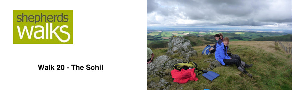
The Schil stands at 601 metres high. This sadly does not make it to the magical 610 metres (2000 feet) high. This is the height when hills are classed as mountains so being just 9 metres short it could not get any closer. The Schil still treats you to some of the finest views in the Cheviots as the ground falls steeply away on each side.
If you visited the summit return to the fence and cross it, taking you back on to the English side.
Turn right and follow the fence on your right. Just as you start to drop down there is a rocky outcrop on your left. If you leave the path and look around the back of this you will see a small brass plaque in memory of Steve Bertram, who died on the 20/11/99.
Continue following the fence on your right as you drop down. Away to your left you get your first view of the College Valley.
You drop down to and cross a stile before you follow a short length of the path that has been improved under foot to help reduce further erosion on this popular path. Continue on following the fence on your right.
The scree on the opposite side of the College Valley at it’s top is called the Hen Hole.
The path that we want is located just before a small red-coloured valley on your left. We will return back to it, but if you have the time it is well worth a short detour to the Mountain Rescue Hut situated at the head of the valley, just a little way on.
The Mountain Rescue Hut that stands here today replaced an old railway wagon. This was placed on the other side of the border fence by the Border Rescue team in 1971 and was brought up by tractor. The present hut replaced it in 1988 after being airlifted in by helicopter from Mounthooly in the College Valley. If you venture inside you will find a guestbook which is filled in by the walkers who have stayed overnight. As it is so near the end of the Pennine Way it often becomes an overnight stop for people who don’t think they will make it to Kirk Yetholm that day.
Return back to the red valley (Red Cribs) you passed earlier and immediately after it turn right down the path to the valley floor below. Red Cribs was known as ‘a passage and hyeway for the theefe’ as late as 1597 as it was a common route for the Border Reivers to use as they left England with their loot.
As you hit the valley floor you can see the old and new right next to each other. The old stone, circular sheep stell and the modern metal tin shed. These will be used for exactly the same purposes but in different generations.
During the lambing season sheep that have had a bad lambing or have lost a lamb, therefore requiring another one mothering on to them, will be put in this small hut. It will have hay and water present in it and will provide shelter for both the sheep and it’s lamb. The sheep stell would have served exactly the same purpose in the past but with no roof.
Cross the small burn, which runs under the path in a large pipe. Turn left after this at the marker post and follow the prominent path with the burn on your left.
Continue on, crossing the burn again and follow the path that runs parallel to the College burn, which is on your right.
You pass a large green container on your right. This will be used to store feed for the livestock over the winter. The container has been strapped down to stop it from being blown away in the high winter winds.
Pass through a tall gate in to a newly planted area and continue on the prominent path.
This area has been ‘wilderness planted’ in 1995. It has been done to recreate the natural vegetation once found in this valley. There is a very good information board on your left just as you leave the plantation.
Leave the plantation through a large gate next to the information board and continue along the bridleway (i.e. don’t go down to the gate to your right).
Continue along the track and bear right at the fork (i.e. don’t go through the gate taking you into the plantation) and go to and pass through a large wooden gate. You pass below some sheep-handling pens as you continue along a lane with the College burn away to your right and a plantation on your left.
Pass through a large gate and continue on, passing a house called Mounthooly on your right.
You come down to the road and bear left along it.
Pass through the large wooden gate and continue on sticking to the road as you make your way down the valley. After a while you pass over a cattle grid.
On the wall next to the cattle grid you can see it has two strands of wire on posts against it. As the wall has got older it has started to ‘slouch’ and has just dropped down a little. This can just be enough to make it not stock proof, making it easy for sheep to jump over. Therefore by putting these two strands of wire on the wall it will stop this problem.
You cross another two cattle grids before passing ‘Fleehope’, a prominent white dormer bungalow.
Just after this you pass some sheep-handling pens on your right, which are situated under a large roof. It is an expensive luxury and quite rarely seen but it can make the shepherd’s job far easier, especially at shearing time when the wool has to be taken off the sheep when it is dry. It can be a frustrating time of the year if you are getting plenty of rain showers. Hopefully with covered pens if you get your sheep in dry you know they are going to stay that way.
Continue on, passing through the metal gate.
Away to your right, across the river you can see the farm of ‘Southernknowe’. You can see how the fields around the farmstead have been cultivated and improved to produce a far more productive pasture. These fields can therefore hold far more stock than the rougher hill ground. This will be invaluable at such times as lambing where it will make it far easier to have a number of your sheep (usually those carrying twins) a little nearer home, so that the shepherd can keep a watchful eye on them.
As you continue down the road you come across the War Memorial, which is situated opposite the village hall.
The memorial is in memory of the allied airmen who lost their lives in the Cheviots 1939 – 1945. On the top of the memorial stone is an informative map indicating the location of all the air crashes in the Cheviots during the Second World War.
Continue on the road as you continue down the valley.
The College Valley is often considered the wild heart of the Cheviots, not only for its harshness but also in the past it was often visited by the Border Reivers, giving it nearly constant warfare for over three centuries until the end of the 16th century.
Robbery and blackmail were everyday professions, raiding, arson, kidnapping, murder and extortion an accepted part of the social system.
While the monarchs of England and Scotland ruled the comparatively secure hearts of their kingdoms, the sword dominated the narrow hill-land between. The tribal leaders from their towers, the broken men and outlaws of the mosses, the ordinary peasants of the valleys, in their own phrase, 'shook loose the Border'. They continued to shake it as long as it was political reality, practising systematic robbery and destruction on each other.
Continue on the single-track road, ignoring all the paths leading from it and eventually you will return back to your car.
Revised Dec 2003